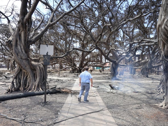
The fast-moving wildfire that roared down the west side of the in Hawaiian island of Maui, all but obliterating the town of Lahaina, stunned almost everyone. Few people, including long-time residents, had any hint that this tropical island could burn with such ferocity. Many other places are at risk of such a deadly and unexpected inferno.
Across the U.S., millions of people—from the Jersey Shore to the prairies of Montana—are unaware that they are living in a high-fire-hazard zone. With a dangerous combination of drought, abundant vegetation and high winds, communities in these places could experience a disaster like the fire that killed more than 100 people in Hawaii. Climate change, often accompanied by land mismanagement, is increasing the odds of such blazes. The potential for tragedy increases further as humans move deeper into fire-susceptible wildland areas.
Hundreds of small- to medium-sized towns across the country are at risk, says Daniel Swain, a climate scientist at the University of California, Los Angeles. Some of them are where you would expect, such as in the flammable foothills of California. “But others would probably surprise even those who live there,” he says.
The residents of Gatlinburg, Tenn., did not anticipate the firestorm that engulfed them in 2016. The town is perched at the northern edge of Great Smoky Mountains National Park. The mountain range is named for the fog that often hangs over its dense forests, and the area typically enjoys abundant annual rainfall. Late that November sparks on a trail in the park ignited a blaze that spread rapidly toward the city. The fire was fueled by powerful winds and the region’s worst drought in nearly a decade. Victims said flames on the horizon erupted into a solid wall in less than a minute. The complex of fires known as the Great Smoky Mountain wildfires claimed 14 lives in one of the largest natural disasters in Tennessee history.
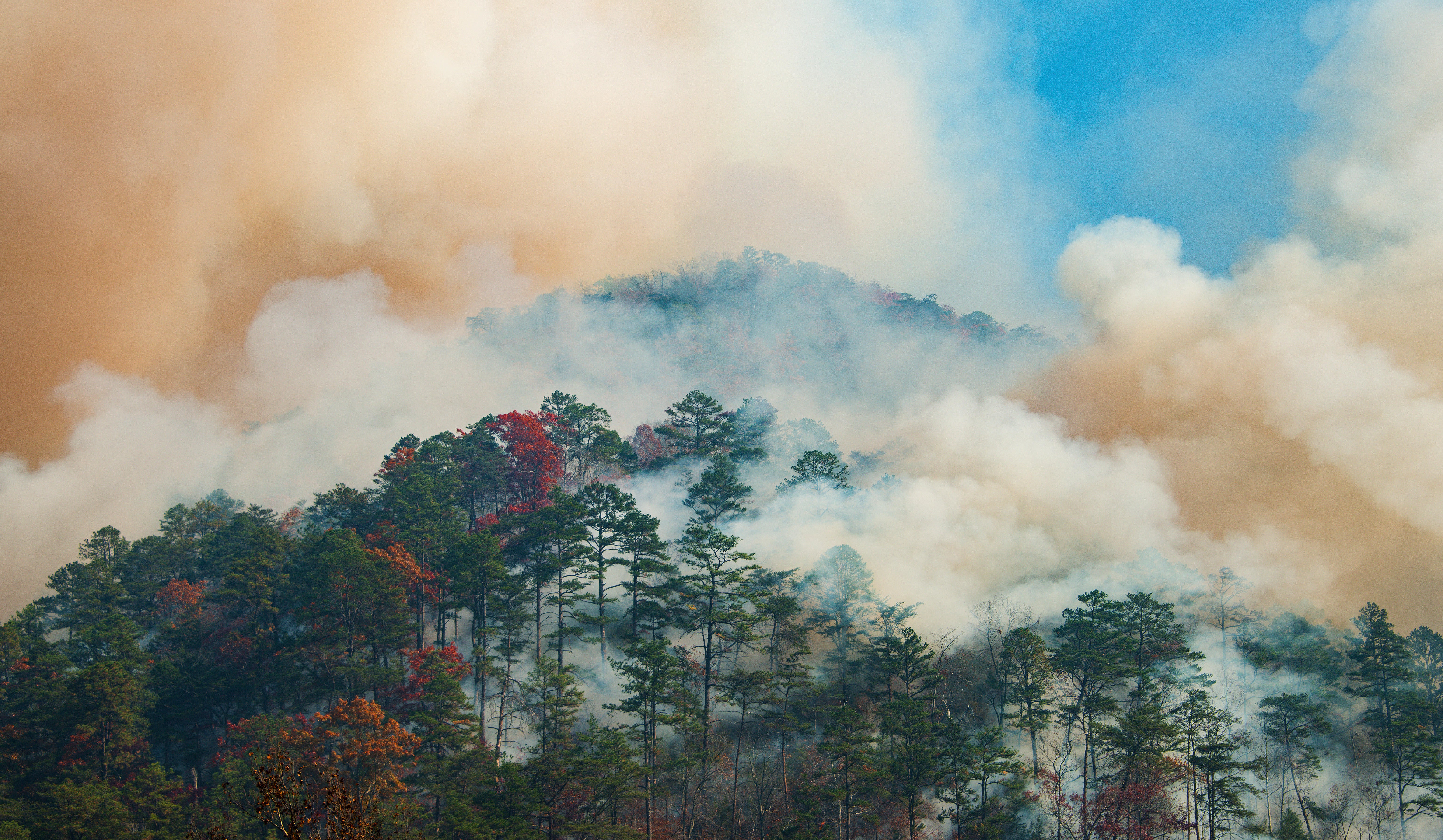
As in Maui, the landscape around Gatlinburg had dried rapidly in what scientists call a flash drought, which was caused by a combination of heat, low humidity and high winds. On the day the fire exploded, humidity values in the area dropped to as low as 17 percent, and a National Weather Service report predicted wind gusts up to 40 miles per hour for the following day. That combination is ominous for extreme fire, says Jason Otkin, an atmospheric scientist at the University of Wisconsin–Madison. Because flash droughts occur abruptly in places where they are least expected, they pose unique challenges. “People have little to no time to prepare for their adverse effects,” Otkin says.
As climate change continues to warm the atmosphere, the air is sucking more and more moisture out of forests and other vegetation that act as wildfire fuel. Scientists call this phenomenon the vapor pressure deficit. As that deficit increases with rising temperatures, it exacerbates flash droughts.
“What these catastrophic wildfire disasters are revealing is that nowhere is immune to the issue,” says Kelsey Copes-Gerbitz, a postdoctoral researcher at the University of British Columbia’s Faculty of Forestry.
Throughout the Appalachians, climate-fueled drought has created conditions for fire risk that rival those typically seen in the West, says Park Williams, a bioclimatologist at the University of California, Los Angeles. The parch begins in autumn, just as trees across the region shed their colorful leaves—a highly flammable fuel for wildfires.
Swain says another “lesser-known candidate” for a Maui-type disaster is the New Jersey Pine Barrens. In precolonial times, fires would sweep through the million-acre Pinelands National Reserve every 50 years or so. Over the past century, however, land managers have suppressed natural fire to the detriment of such iconic species as the pitch pine, which evolved to prosper in droughty, acidic and fire-prone conditions.
Today these pines are paradoxically vulnerable. The suppression of fire has created a vast reserve of flammable vegetation. Rising temperatures, a thirstier atmosphere and the expansion of communities around the edges of the reserve put the Pine Barrens at risk. “If the winds pick up, and we get an ignition, it can really move. And it can get ugly,” says G. Russell Juelg, senior land steward at the nonprofit New Jersey Conservation Foundation.
Even the dense boreal forests of Wisconsin and Minnesota are candidates for unexpected wildfire. This summer National Oceanic and Atmospheric Administration meteorologists reported that drought had reached the “exceptional” category—the highest drought designation—in Wisconsin for the first time ever. June is normally the wettest month in Wisconsin, but this past June was one of the driest on record. Wisconsin is in a flash drought, says Steve Vavrus, the state’s interim climatologist.
Though the primary worry right now is the effect on crops, in a state boasting 17 million acres of forests, the threat of wildfire is never out of mind. Wisconsin was the site of the Peshtigo Fire, the U.S.’s deadliest on record. After an extremely dry summer, some accounts say sparks from a train running from Peshtigo to a harbor in Green Bay ignited brush beside the tracks in October 1871. Small fires exploded and, driven by winds that reached 100 mph, turned into a firestorm that was three miles across and 1,000 feet high. The Peshtigo fire burned up to 1.5 million acres and killed an estimated 1,152 people.
The vast, windswept stretch of open land known as the Northern Great Plains is another place most people don’t expect a town-destroying wildfire. The region, which includes large parts of Montana, North Dakota and South Dakota, is a patchwork of wetlands, short- and mixed-grass prairie and heavily forested lands in mountainous areas. Throughout history, fires were frequent but burned at low intensity. They were held in check by grazing bison that reduced the amount of flammable vegetation.
Although the Northern Plains have not historically been on the list of places where fires are likely to become wildfire disasters, it’s time to revisit that notion, Swain says. The largely rural area is increasingly fragmented with roads and human settlements, and it has experienced flash droughts. Grass fires do not typically have the intensity of forest fires, but when they occur near towns, they pose the risk of igniting houses.
As human populations move deeper into areas once considered wilderness, warning people of wildfire is critical. Nowhere is the alert system more sophisticated than in California, Swain says. State and private agencies have installed a system of more than 1,000 tower-mounted cameras, called ALERTWildfire, to look for smoke and flames so fires can be attacked before they can rage out of control. The California Department of Forestry and Fire Protection (CAL FIRE), one of the world’s largest firefighting agencies, enforces fire protection at private homes in high-risk areas by inspecting individual properties. But even there the technology is often outrun by the intensity and speed at which fires erupt. The challenge is getting information to people fast enough. “Sometimes fires move faster than our information systems can accommodate,” Swain says.
Though exactly what happened in Lahaina will take time to fully investigate, it is clear that emergency sirens were not activated; cell phone towers and relays burned or lost power; and evacuation routes were blocked by flames and downed power lines. State guidance on disasters had information regarding tsunamis and hurricanes but not wildfires, even though the government had acknowledged the real danger of a fire just like the one that ended up occurring. According to residents, there were no specific wildfire evacuation plans. Some experts have also noted the lack of strong efforts to control the invasive grasses that provided fuel for the fire.
When flames were heading toward Gatlinburg in 2016, the city fire department activated its four sirens, which had been installed in case of flooding. All were located around the downtown business district and didn’t echo into the surrounding neighborhood, so most people didn’t hear them. Attempts to send evacuation alerts were frustrated by a breakdown in communications among city, state and national park officials. Since then the city has installed more sirens and expanded its CodeRED alert system to send text messages.
In New Jersey the state Forest Fire Service has mounted a Firewise USA campaign throughout the Pine Barrens and installed fire towers, which are staffed whenever the forest is dry enough to burn. The program works with state, county and local emergency offices, which send alerts through cell phones and social media, says Caryn Shinske, a press officer at the New Jersey Department of Environmental Protection.
Understanding the circumstances that create fire storms can help us mitigate the risks, says Carly Phillips, a research scientist at the Union of Concerned Scientists. Increased use of forest management strategies, such as prescribed burning around communities and at wildland borders, can help to lower risks of catastrophic outcomes, Phillips says.
Ultimately humans have the technology to solve the overall problems generated by climate change, Swain says. “We know what we need to do can be done, and we’re not too late,” he adds. “But we’re also not doing those things.”
 Rights & Permissions
